|
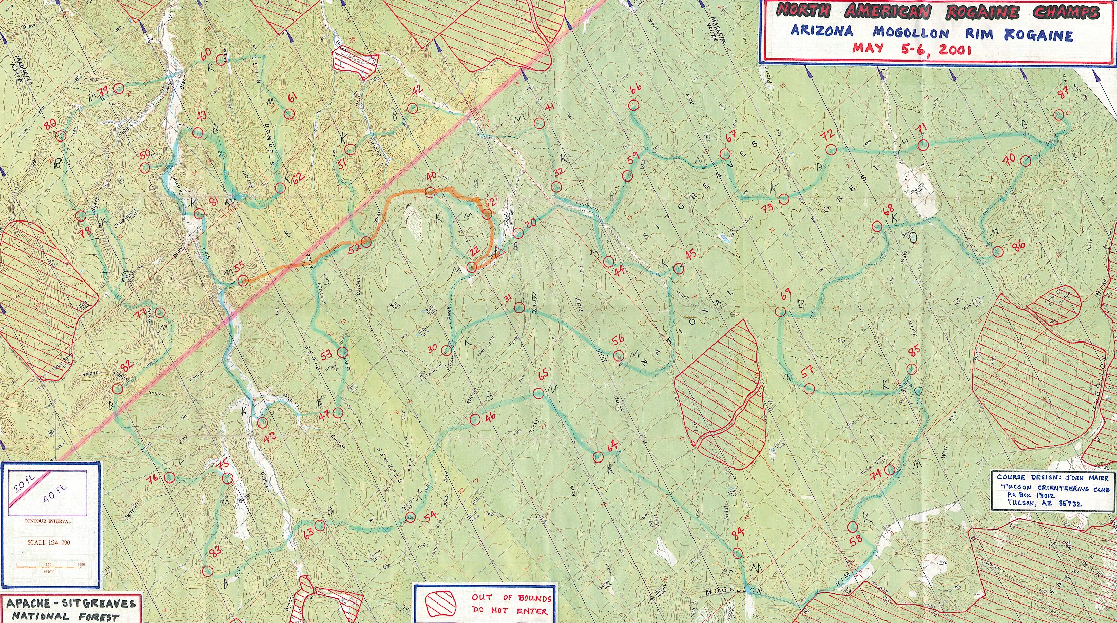
Official Results I'd like to tell you about the 2001 North American Rogaine Championships. But first, let me answer the question that inevitably comes up when talking about this event: "Isn't Rogaine something to do with hair loss?" No, not that type of Rogaine. This type of Rogaine is a form of orienteering. Orienteering involves traveling through a wilderness area with a map and compass. Competitors make their way to various control points on the map, using only their compass and their wits to keep track of where they are. At each control point hangs a uniquely shaped punch, which competitors use to verify that they actually visited the correct spot. In an orienteering meet, solo competitors run to find a set of points in a prescribed order, trying to finish in under three hours. A Rogaine is similar to an orienteering meet, but with some important differences. Instead of lasting under three hours, a Rogaine typically runs for 24 hours straight. Competitors run in teams of two (or more) instead of solo. And the controls are assigned different point values, making the more distant (or difficult) controls more valuable to visit. Teams visit as many controls as they can, in whatever order they wish, within the 24 hour time limit. Some claim that Rogaine stands for Rugged Outdoor Group Activity Involving Navigation and Endurance, but others believe it is derived from the names Rod Gail and Neil Phillips, early pioneers of the sport. Having competed in many orienteering meets, we were eager to travel to Arizona's Mogollon Rim to race in the Rogaine. We had participated in this event the previous year as well, but had been ill-prepared to deal with the swiftly plummeting temperatures that occur on the Rim at night. This time, we were determined to do much better, despite the fact that the competition was expected to be a lot tougher because this year the event had become the North American Championships. When we arrived and started investigating, our suspicions were confirmed: There were a lot of good teams there. Robyn Benincasa was there (from the current World Champion Adventure Racing team Eco-Internet). Team Traveler was there (the reigning North American Adventure Racing champions). We also had some friends there that we expected to put in a strong showing: Bridget Brunnick and Joe Prusatis. Bridget has done more than one Eco-Challenge, and Joe is a legend among the ultra-marathon community. Despite the odds, we felt that our plucky band of competitors had a shot at performing really well. My sister Marcy Beard and I were competing in the coed division. Marcy's husband John Beard and our Adventure Racing teammate Jason Mittman were competing in the men's division. Also competing in the men's division were our pals Art Cook and John Crowther. Finally, we had some friends that were just along for the fun of it all, and were just going to participate in the 8 hour category: Jon Judge, Joe Miller, and William Miller. We all camped overnight in the park. We tried to get in as much sleep as possible before the long race! At daybreak, we ate breakfast and prepared for the start. At 7:45am they handed out the topo maps. Each of us received three maps that showed all the control points. Marcy and I hurried back to the tent to begin plotting our route. Our goal was to make a route that would efficiently hit all the points on the map. However, the expectation was that we wouldn't quite have enough time to actually hit every single point in 24 hours, so ideally the route could be easily shortened at the end to get us back before the cutoff time. We sketched our planned route on the map with a blue highlighter. The start and finish of the race was the triangle in the center of the map. Our planned route started off towards control point 20, then looped around the map in generally a clockwise direction. We liked our route choice for several reasons. We could see that the eastern section would be more difficult to navigate than the western section, because not only was the eastern section flatter, but the contour interval was 40 feet instead of 20. (The contour interval describes how far apart the lines of equal altitude lie. A higher contour interval means that the map reveals fewer details of how the land slopes up and down.) So, we knew that we wanted to tackle the tricky east side during the light of day. Also, our route circled around the edges of the map to hit all of the high-value sections of the map first. The end of our route was all low-value control points, so if we had to cut it short we wouldn't be severely sacrificing our final score. Two hours after getting our maps, we were content with our planned route, and we headed out to the start area for the pre-race briefing. The race director gave some final words of encouragement, and all of our teams wished each other well. Then, at 10am, we were off! The start of a Rogaine is fun to watch, because everyone heads off in different directions. Also, teams vary a lot on the pace they choose to travel, as few (if any) teams will be able to run for the entire course. Marcy and I jogged to control point 20, which was very near the start and wasn't hard to find. We punched our card and headed off for point 59. For the first three control points, we had decided that we would both navigate, to "get in the groove" and get used to the contour scale. After that, we would alternate being the lead navigator at each control point. This allows the secondary navigator time to relax and concentrate on eating and drinking. On the "tricky" control points, we would both navigate. After 66, our third point, Marcy led us to 67. Then I took the lead to 73. We had thought that 73 would be easy, but it turns out that we wasted more time on this point than any other point during the race! 73 was located on a stream. What the map didn't show, however, was that there was another stream running perfectly parallel to the main stream, which we ran into before the main stream. So, we spent about a half an hour searching up and down the wrong stream, before finally going far enough north to find the spot where the streams met, and realizing what we'd been doing wrong. There was even a land ridge that rose up between the two streams that was large enough to hide the main stream, but wasn't quite big enough to make it onto the map (darn those 40 foot contour lines!). Ah well, that's how orienteering goes; you can't always tell how things are going to turn out just by looking at the map. Once that problem was solved, we proceed to 72 and 71 without incident. While we'd been the first team to reach 66, by 71 we were starting to see some other teams now and again. In particular, we spotted another coed team that seemed to be running a very similar route to ours. Their method of getting to the points differed, though. Whereas Marcy and I liked to stick to trails and other handrails where we could, the other coed team tended to go in a straight-shot fashion between points. A case in point would be 87, where we used the trail system to get on top of the ridge and then left the trail to find the point on the ridge. The other coed team came straight up from below instead. We saw them again at 70, and intermittently for the next six points or so. Between 85 and 74 there was a small lake, where we refilled our water supply. This was perfect timing, as we had been going through water fast during the heat of the day. It was a little murky, but after you throw in some iodine to purify it and then some drink powder, it becomes palatable enough. A couple other teams went by while we were at the lake, but none of them refilled. Maybe they knew of a better spot to get clean water, or perhaps they were just hoping to find a better spot! After refilling, we headed south on the trail towards 74. In a nice surprise, we ran into John and Jason, who were coming north on the trail towards the lake! It turns out that they'd started with the east side of the map as well, but had elected to do a counter-clockwise loop. They said that they'd wasted a ton of time on point 84, but that it was in the correct place. Well, we'd find out soon enough. It was Marcy's turn to navigate when we reached point 84, and she hit it flawlessly. But we could see why it could have been difficult coming from the other direction, as John and Jason did. There were several trails in the area that weren't on the map (an all-too common difficulty in orienteering!), which made the area rather confusing. It was getting late in the afternoon, so we moved quickly to get all the points we could before the sun went down. 65 was at a fork between two large streams, and 54 was at the corner of a small horse corral. The sun went down as we found 63, and by the time we'd traveled into the canyon it was dark. We stopped to put on our headlamps and some warmer clothes, as we knew from last year that it gets cold quickly at this elevation. We mixed up a bottle of Spiz, which is a new energy drink we've been experimenting with. On the way to 83, we had to climb over our first major ridge. It would not be the last! The whole western section of the map was ridges and gullies, and there would be a lot of elevation gain and loss to reach the checkpoints. We were happy we had chosen to do this section at night, because the navigation was relatively easy, but the actual traveling was slow going. Since you naturally slow down at night anyway due to the low visibility, it was as if we weren't being penalized at all by the darkness. All night long we seemed to follow the same pattern. Starting from a point that's in a gully, we'd climb up to the top of a rocky ridge. We'd cross a path that was not on the map, then we'd cross a fence, then we'd find a path that actually was on the map. We'd follow that path for a bit, then we'd leave the path and head down into another gully. We'd find the next checkpoint in the gully. Then, the whole pattern would start all over again. We did a whole lot of climbing, but there really wasn't any way to avoid it. The values of the check points reflected this, as we were checking off a long string of 70's and 80's, which were the most valuable points in this Rogaine. In the middle of the night we once again had perfect timing in finding a water stop. Between 77 and 78 there was an actual water tank just off a main road. We think it was designed to collect rain water. At any rate, its walls were 10 feet high, and there was no obvious faucet on it. But, on the back side of it there was a ladder that went right to the top, so I climbed up and sure enough, it was filled to the brim with clear, cold water. What a treat! We crossed through the huge Black Canyon on the way to 60. At this point, we were getting pretty tired of the hills, and the slope leading up to 60 was the steepest yet. But Marcy tackled it with aplomb, not wanting to waste any time going out of our way to find an easier route to the top. On some of the slopes I could assist Marcy with a tow rope, but on a lot of the slopes the footing was too precarious to do this effectively. I was looking forward to 62, as the map showed it as being in a depression. Last year at this same event we had our first experience with Mogollon Rim depressions, and they were rather impressive. Huge holes, up to 100 feet deep, with steep sides. Surely, this would be a point that we could not miss! But, we were thrown for a loop again, as the depression at 62 was only about 2 feet deeper than the surrounding land. We missed it on our first couple attempts, and eventually we had to go back to the closest trail intersection and pace count our way to it. Fortunately, Marcy has gotten very accurate with this technique, so she guided us right to the spot where we needed to leave the trail. We laughed at how puny this depression was compared to the ones we were used to from last year. It was becoming clearer at this point that we wouldn't have time to get all the points in the few hours we had left. We decided to keep following our original plan for a bit, since 43 and 50 were so close together and they led to the last big point, 81. Unfortunately, we went down the wrong valley to 43, but by then the sun had come up and we were starting to move a bit quicker. So, it was back up the correct valley to 43, then across Black Canyon again to 50. We had to cross the canyon once more to get to 81. It turned out that 81 was straight up the steep canyon wall. I did some easy, non-technical rock climbing to reach it (teams that had been smart enough to approach this point from above could walk right to it instead of climbing the wall). That done, we determined that it was time to start heading back. 55 was on the way, and it provided a nice gradual slope to exit the canyon. After 55 we finally deviated from our original planned route (I marked our actual finish route on the map with an orange highlighter), and headed cross country to 52. We kept running into fences we had to cross. They were annoying to me because they were too flimsy to climb, as the posts would just lean over. So the best way to get across them was to hold up the barbed wire and crawl under them. But, to do this you had to take off your pack, and by this time I was getting sick of repeatedly removing my pack and then strapping it back on again. My brain was starting to get mushy from the long night! Onwards to 40, which looked like it was going to be our last tricky point. Marcy was feeling fine, so I gladly let her lead. As we removed our packs and crawled under yet another fence, Marcy said something to the effect of "it's so comfortable lying on the ground that I could take a nap right here". Normally, this would be my cue to say something motivational, like "No time for that! We gotta keep moving!", but instead I said, "Ok, time to sleep!" This was my way of letting Marcy know that at this particular point in the race, it would be up to her to keep us moving towards the finish line! When doing long races, your body and mind go through strong phases and weak phases. The trick is to have team mates that can sense who's currently feeling weak, so the strong members can assist them until they're feeling better. Marcy and I have raced together so much that it's easy for us to know when we need to step in and take the lead when the other has fallen into a mental rut. So Marcy took charge, and kept us moving. By the time we found 40 I was starting to feel a bit better, and we were in the home stretch. We were just about to enter the drainage that led to 21 when up came John Beard and Jason! We were happy to see them, but they had disappointing news: Jason's foot had swollen up after they'd completed the east side of the map, and they'd been forced to spend the night at the tent. They were only just now getting out again to catch a couple last points before the end. We also learned that the team of Art and John Crowther had been forced to sleep because John had been feeling sick. It looked like Marcy and I had been the only ones who had been able to keep traveling all night. We found 21, and went by the finish area to fetch 22. We'd been considering heading down the road to capture 30, but 22 took us so long to find (and it should have been easy!) we decided not to push our luck. Besides, another coed couple had punched 22 just ahead of us, and we wanted to see if we could beat them back to the finish area. As we started speed walking to catch up to them, they suddenly began to jog for the finish. We started to jog as well (an actual sprint for the finish line!), but they were way too fresh for us to catch them at that point. We decided that either they were really, really good, or that they had slept sometime during the night. We found out later that they had indeed taken a nice long nap to refresh themselves. We turned in our punch card with plenty of time to spare before the 24 hour cutoff. We got to eat some "real" food, which was a nice treat. I took a short nap before the awards ceremony. We were extremely happy with our performance: We'd gotten all the 80's, 70's, and 60's, which was where the bulk of the potential points were. And, we'd managed to keep moving forward for the whole 24 hours, without even taking a nap. We'd heard that one of the male teams had found all the checkpoints, with a couple of hours to spare! Turns out that they weren't the only ones, either. There certainly were a lot of good teams out here! I didn't think we'd place, given the level of competition and the fact that we'd been moving so slowly during the last half of the course. But, as the officials kept hanging up the completed score cards, to our surprise Marcy and I stayed in third place! Third best team on the continent, what a thrill! It turned out that the first place coed team was the one we had seen repeatedly on the eastern section of the course. They had even stopped to take a short nap during the night, but they'd still been able to beat us because they were able to keep up a consistently strong pace for the full 24 hours. And, presumably, they made a couple less mistakes! It was a great learning experience for us to see them in action, because we now know that we were moving just as fast as they were during the first half of the race. We just have to work on keeping our speed up for the full 24 hours. We came in 3rd out of 33 coed teams, and compared to the male teams we would have placed 8th out of 40. We even beat Team Traveler's team (which was a treat, because they'd beaten us the last time we met in an adventure race!), and Robyn Benincasa's team! (Though we heard later it was Robyn's partner that was slowing her down, so we can't claim to be better than the world champion just yet!) Bridget and Joe took themselves out of competition because they had to leave early, so they couldn't stay out for the full 24 hours. We felt bad for our other team mates, who hadn't lived up to their potential due to rotten bad luck. But everyone had fun, and we're all eagerly looking forward to the next big Rogaine. Next time, we're all gonna kick some butt! |